|
|

|
|
|
|
|
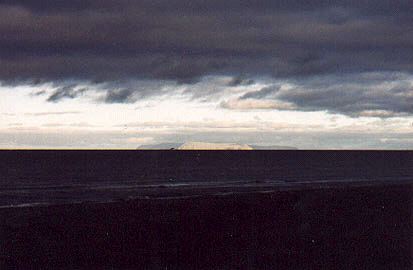
Diomede Islands Little Diomede Island stands out in sunlight 25 miles away, with Big Diomede under clouds two miles beyond. Russia's Siberia is 55 miles from Wales. |
Playground by the Sea The playground in front of the school has an enclosure for the youngest students. Fairway Rock, a source of eggs since early times, rises 534 feet 17 miles due west. |
Wales School Kingikmuit School serves pre-school through grade 12 students. Before the mid-1980s, students went to Nome, Sitka, and other areas for upper grades. |
|
Parsonage and Church Thornton Chapel, with the parsonage on the left, was first Congregational, then Presbyterian, and now Lutheran. |
"The Dome" Ootenna Community Center (1985) was named for George Ootenna, a herder, artist, and respected village leader, who worked with Tom Lopp. |
Town Street Main Street, the only road through town, passes most homes, the school, and community buildings. There are few vehicles larger than ATVs (all-terrain vehicles). |
|
The Razorback "Razorback" is a hill on the northern side of Cape Mountain. |
Tundra Color 1 Low plants show fall colors on the side of Cape Mountain. |
Tundra Color 2 Cape Mountain to the south drops off into Bering Strait. |